
06 Oct Underground utility risk in grid interconnection projects
By Dr. Cam Raufi, Founder and CEO, Prezerv Technologies
Getting a generation or storage project through the interconnection queue takes time. Lawrence Berkeley National Laboratory reports that 2,061 GW of generation and storage capacity was actively seeking grid interconnection at the end of 2025. The median time from request to signed interconnection agreement exceeded three years in 2025.1 Developers have good reason to protect the design and construction schedule that follows.
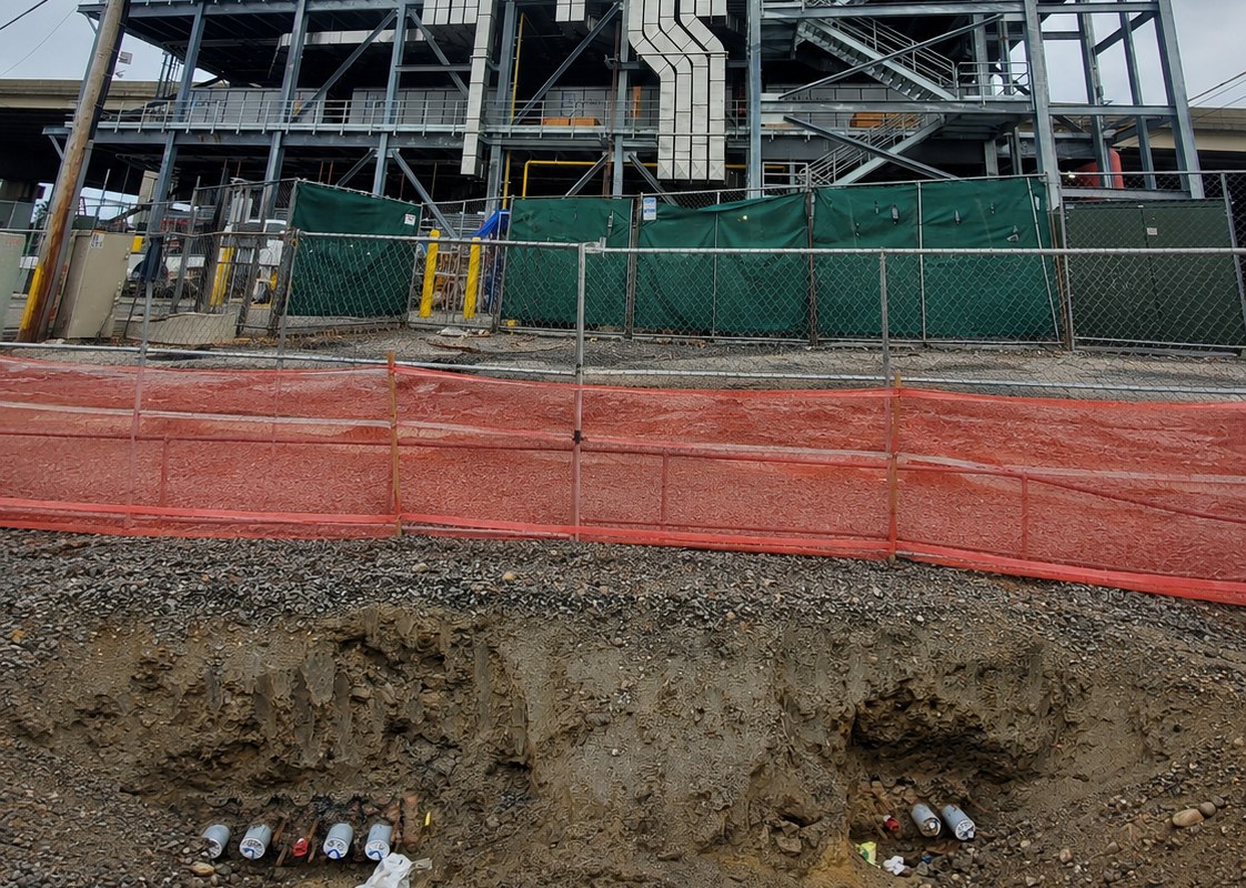
Buried utilities create a separate risk during project design and construction. Gen-tie routes, collector systems, substation expansions and access roads can cross or sit near electric, gas, water and telecom lines. Incomplete or inaccurate records can hide conflicts until construction, when resolving them may require redesign, relocation and delay.
This brief explains where underground conflicts arise, why records alone are not enough, and how to improve subsurface information before each major design decision.
Where buried utilities show up in an interconnection project
Conflicts are especially important where a route enters an existing utility corridor or a project modifies an operating substation. Typical locations include:
- Gen-tie and collector routes that cross roads, rail corridors and existing distribution lines.
- Substation and switchyard expansions at the point of interconnection, where grounding grids, conduit and foundations go in next to existing energized equipment.
- Directional drills and bores under roads and waterways, where an unknown line in the bore path is a safety hazard as well as a schedule problem.
- Access roads, laydown areas and drainage that cut across older water, sewer and telecom lines.
Experience in transit illustrates the consequences. A Federal Transit Administration review documented a bus rapid transit project with 460 days of delay because utility relocation work could not be designed, permitted and completed on time.2 This was a transit case, not an energy project or a Prezerv result. It shows why identifying conflicts early must be paired with utility-owner coordination and a relocation plan.
Why records alone are not enough
The ASCE 38 framework distinguishes four utility information quality levels. Its 2022 edition is ASCE/UESI/CI 38-22, Standard Guideline for Investigating and Documenting Existing Utilities. The table below gives a practical summary using FHWA explanations;3 the responsible professional should apply the specified standard to the project deliverable.
| Quality level | What it means |
|---|---|
| QL-D | Existing records and recollections; locations have not been confirmed by field investigation. |
| QL-C | Surveyed visible utility features correlated with records using professional judgment. |
| QL-B | Appropriate surface geophysical investigation, surveyed to project control, to establish utility presence and approximate horizontal position. |
| QL-A | Utility exposure and survey to establish precise horizontal and vertical location and relevant attributes at specific points. |
QL-B information does not, by itself, establish a verified vertical position. QL-A verification establishes measured locations at specific exposure points; it does not verify the utility between them.
Records and surveyed surface features are useful starting points. They may still leave enough uncertainty to affect routing, foundation placement or excavation planning, especially where abandoned or private lines are absent from the records. The investigation scope should follow the consequence of a missed conflict.
What getting it wrong costs
Damage to buried utilities has consequences beyond the repair bill. In August 2026, the Common Ground Alliance modeled annual U.S. economic impact at $83.2 billion under a higher-reporting scenario, with direct repairs representing 5.9% of the total.4 The estimate includes wider business, human, community and environmental impacts. It describes national exposure, not the expected loss on an individual project.
Early investigation also has supporting evidence. A Purdue University study for FHWA, published in 2000, examined 71 highway projects and quantified $4.62 in savings per $1 spent on subsurface utility engineering (SUE).5 The historical result supports evaluating SUE early; it is not a return forecast for an energy project.
A stage-by-stage plan for interconnection projects
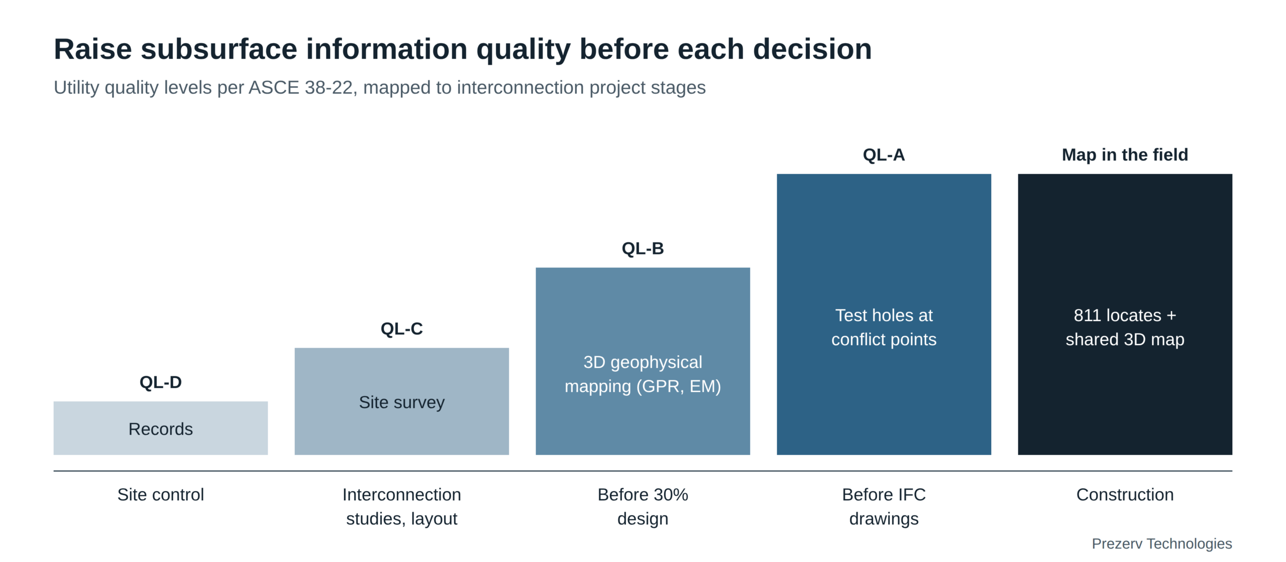
Match the investigation to the decision and the consequences of a missed conflict. The sequence below is a planning approach, not a schedule prescribed by ASCE 38. The project engineer should set the scope, quality levels, verification points and acceptance criteria.
1. Site control and feasibility.
Collect utility-owner records, easements and available as-built drawings for candidate routes and the point of interconnection (QL-D). Record missing or contradictory information and assign responsibility for resolving it before committing to a route.
2. Early layout and site survey.
Survey visible utility features and correlate them with the records using professional judgment (QL-C). Investigate discrepancies and coordinate with utility owners. A site walk alone is not a QL-C survey.
3. Before the route and layout are fixed.
Commission a qualified utility survey provider to carry out geophysical investigation of the selected corridors and substation footprint (QL-B). The provider may combine ground-penetrating radar (GPR), electromagnetic locating and other methods suited to the site.6 Request a 3D map aligned to design coordinates, with depth where the data support it and explicit gaps and limitations, so designers can route around conflicts while the layout is still flexible.
4. Before construction drawings are issued.
Use targeted exposures and survey at critical crossings, foundations and uncertain locations to obtain QL-A information. Compare the results with the design and resolve clearance or relocation requirements with the utility owner. Continuous depth mapping shows where exposures are actually needed, so they can be fewer and better placed; the engineer determines how many are required.
5. Construction and handover.
Complete the applicable 811 notification and response process, follow local safe-excavation requirements, and give crews access to the same 3D map the designers used, with its limitations. Update the project record as utilities are exposed, relocated or installed. A design map supplements the excavation protection process; it does not replace it.
Where AI fits
Interpreting radar data is often the slowest part of geophysical investigation. Specialists must distinguish utility responses from soil conditions, clutter and other features. If interpreted results arrive after routing decisions, the opportunity to avoid a costly conflict is significantly reduced.
Prezerv’s AI-powered software interprets radar scan data and creates 3D maps of underground utilities.7 It maps large areas quickly, in 3D and with depth, at inch resolution. The purpose is to turn survey data into information designers can use while routes and layouts are still flexible.
That output sits between the ASCE 38 levels, what is sometimes called QL-B+. It goes beyond QL-B because it shows depth as well as horizontal position, continuously across the scanned area, so there are no blind spots between test holes. It is not QL-A, because nothing is physically exposed, and QL-B+ is industry shorthand, not an ASCE 38 quality level. In practice, routing is more efficient and significantly fewer test holes are needed to confirm the design, with exposures still used at critical conflict points.
AI cannot recover information that was not captured in the field. Signal quality is affected by soil properties, moisture, target material, burial depth and interference.8 Qualified professionals review the results and decide where additional investigation or exposure is needed. AI does not replace that judgment or the 811 process; it gets better information to the people making decisions early enough to matter.
What to request in the survey deliverable
- Coverage and control. Survey limits, methods, collection date, design coordinate system and vertical datum.
- Reliability. Quality levels by utility segment, the basis for depths, and documented uncertainty or unknowns.
- Validation. Exposure or other verification results, with mapped positions distinguished from measured ones.
- Design decisions. A conflict list, proposed verification points, utility-owner coordination needs and accountable owners.
- Handover. CAD or GIS data in the agreed format, professional review, and a process for updating the record in the field.
Frequently asked questions
Does an interconnection study identify underground utility conflicts?
Electrical interconnection studies evaluate grid impacts and required system upgrades.9 Do not assume they include field investigation of buried utilities. Confirm the scope and commission subsurface investigation for the project routes and construction footprint where needed.
What quality level of utility information do I need before design?
Use the information quality needed for each decision. QL-B investigation, ideally with depth, is useful for assessing route and layout conflicts; critical clearances and uncertain locations may require QL-A verification earlier. The project engineer should set the scope and acceptance criteria.
What is QL-B+?
QL-B+ is industry shorthand, not a level defined in ASCE 38. Prezerv uses it for 3D geophysical mapping that adds depth to QL-B’s horizontal positions across the whole scanned area, without the excavation QL-A requires. Test holes are still used to verify critical low-confidence points, and the deliverable should state quality levels, depth limitations and locations requiring verification.
Is 811 enough?
811 is essential before excavation, but surface marks are not a complete design survey or a depth model. Coverage of private facilities and other services depends on the local system and project; confirm what is covered and arrange additional locating where needed. Design-stage information may also be available through the local one-call center. Follow its current requirements.10
Discuss the next decision on your project
If you are developing a generation, storage or substation project, request a project review with Prezerv. Tell us briefly about the site or route and your next design milestone, and we will get back to you within 24 hours. We will then discuss where subsurface uncertainty affects the decision and what investigation or verification would be useful.
Sources
Lawrence Berkeley National Laboratory, “Backlog of power plants seeking transmission grid connection eased somewhat in 2025 amidst high withdrawals,” July 1, 2026. https://emp.lbl.gov/news/backlog-power-plants-seeking-transmission-grid-connection-eased-somewhat-2025-amidst ↩
Federal Transit Administration, Utility Relocation: Challenges and Proposed Solutions, Final Report, March 2022, pp. 2–3. https://www.transit.dot.gov/sites/fta.dot.gov/files/2022-03/Utility-Relocation-Challenges-and-Proposed-Solutions.pdf ↩
Federal Highway Administration, quality level definitions (ASCE 38 framework). https://www.fhwa.dot.gov/programadmin/htmldoc3.cfm ; ASCE/UESI/CI 38-22. https://ascelibrary.org/doi/book/10.1061/asce38 ↩
Common Ground Alliance, Between the Lines: The True Cost of Damage to America’s Buried Utilities, August 13, 2026 (press release). https://www.einpresswire.com/article/933922254/new-report-underground-utility-damage-costs-america-83-2-billion-a-year-nearly-triple-previous-estimate ↩
Purdue University, Cost Savings on Highway Projects Utilizing Subsurface Utility Engineering, FHWA-IF-00-014, January 2000. https://www.fhwa.dot.gov/programadmin/purdue.cfm ↩
FHWA, Sample State/Consultant Agreement, sections on geophysical accuracy and project scope. https://www.fhwa.dot.gov/programadmin/htmldoc3.cfm ↩
Grid Catalyst, Prezerv portfolio profile. https://gridcatalyst.org/portfolio/prezerv/ ↩
FHWA, Sample State/Consultant Agreement, sections on geophysical accuracy and project scope. https://www.fhwa.dot.gov/programadmin/htmldoc3.cfm ↩
FERC, Explainer on the Interconnection Final Rule. https://www.ferc.gov/explainer-interconnection-final-rule ↩
CGA, Before You Dig https://811beforeyoudig.com/Before-You-Dig/ ; Gopher State One Call, Ticket Types https://gopherstateonecall.org/ticketing/ticket-types/ and Private Utility Locating https://gopherstateonecall.org/private-utility-locating-what-homeowners-need-to-know/ ↩